Sunday, July 29, 2012

The Trent-Severn Heritage Canal

When we left Kingston, we had a choice of 2 routes to Trenton and the beginning of the Trent-Severn. The northern route, though trickier (rocks), is shorter and more protected, so we chose it.  Part of the way across, our navigation system chart stopped showing any detail.  John considered moving out to the southern route, but Mary convinced him that we can still navigate with paper charts, so he agreed.  Canadian buoys are much harder to see than ours and when they show up on the nav computer, you can tell right where to look with the binoculars.  Without it, we spend more time scanning with the binoculars.  We were doing fine, going slowly; John asked every few minutes if Mary would put her finger on the chart to show him where we were.  2 big power boats cruised out of a bay and passed us, so we decided to follow them and travel on plane for a while.

Within 15 minutes, the lead boat passed under a bridge and instead of going on the left side of the river, as the chart showed, he veered right.  We slowed down and followed the correct course, as did the other boat.  Pretty soon both boats pulled out of the channel and stopped, so we motored by.  We heard them on the radio off and on the rest of the day, trying to locate a lift so the props on the first boat could be checked.  We stopped for fuel in Trenton:


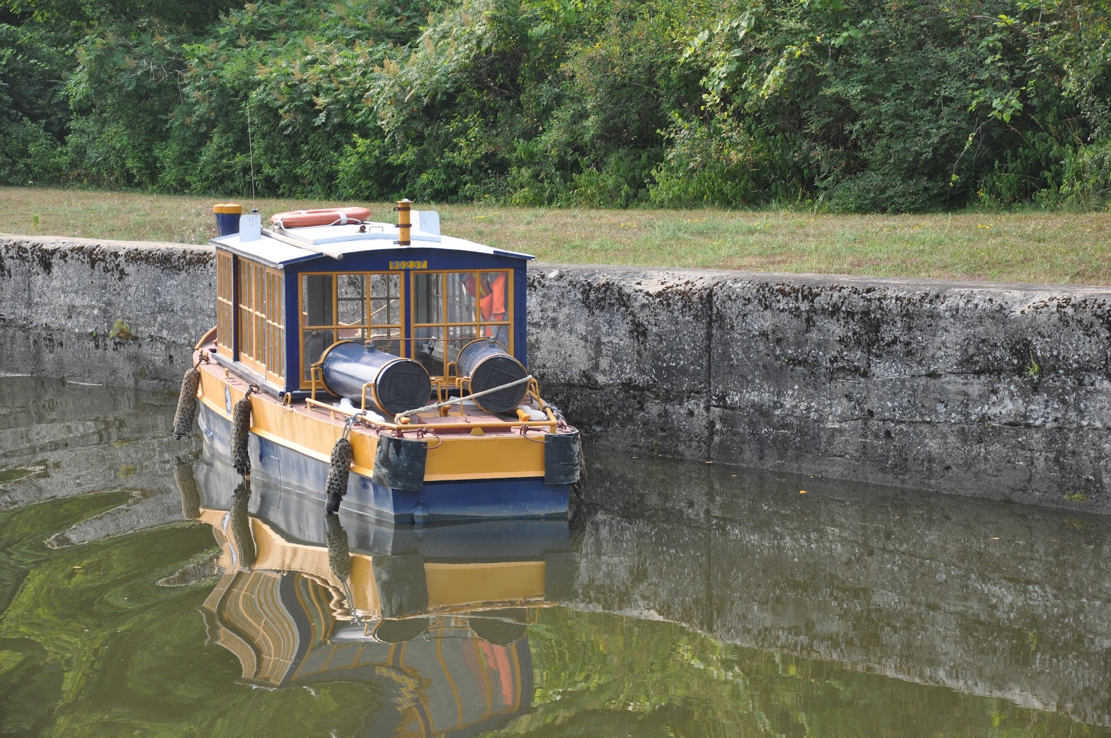
This 240 mile long waterway was begun in 1833 and took 87 years to complete.  By the time it was finished, railroads and roads had rendered it obsolete for commercial purposes but it is a pleasure boater's dream.  Most of the locks still have hand-cranked lock doors:


Through the first 6 locks and 7.3 miles, we tie up at the lock wall near Lock 6 which recently added electricity.  We heard calls on the marine radio between 2 boats back in Trenton wondering why horns were being blown at them.  They thought maybe the lock was malfunctioning so called a local marina on the cell phone.  Turns out they were throwing too much wake and the harbormaster warned them they were in for a talking-to when they reached the first lock.  They later joined us here.  John walks across the upper lock wall to go to the small town of Frankford:


Mary Frances at the lock wall.  We had planned a one night stay, but rain fell pretty much all day Thursday, so we stayed put.  That beautiful willow tree dropped lots of leaves on our bow and John had to scrub the stains off in Campbellford:


Friday we left pretty early.  The only signs of life on the other 2 boats were the captains, who offered us a hand getting away.  They soon caught up with us, as we were being cautious.  We decided to follow them on plane for a time, as they know this water.  The first one passed us at the speed that throws a giant plowing wake and got up on plane when they were about half-way past.  The second boat radioed that they would slow way down for the pass, which they did but they, also, got up on plane too quickly and tossed us around some.  We followed them only a short way, as we try to be considerate of boats on shore and small fishing boats and they were not slowing down.

You really do want to stay in the channel, as there are plenty of rocks:


When it's a short distance between locks and we're traveling slowly, Mary stays on the bow, enjoying the sunlight (and saving her hip):


Our last lock of the day is a flight lock, 2 locks that share a door.  We are raised first in one chamber, then the big, blue door opens and we drive right into the next lock:


Looking behind us down at the 2 locks as we reach the top:


We arrive in Campbellford and try to use our calling card to contact the gentleman who rebuilt our navigation computer in 2010.  The card does not work in the pay phone and the per minute charge will be $5.00 so we go back to the tourist information center where we paid for our dockage and electricity and ask to use the phone.  Guess what-the calling card doesn't work there, either.  The delightful young woman "manning" the office tells us to just put the call through.  The next concern we have is that this guy never answered his phone when we were in contact with him a couple of years ago-we always had to leave a message.  It's after 4 o'clock on a Friday-what are the chances?

He actually answers the phone and explains that even though our original cd's included Canadian waters, the system has been revised so they are now separate (surely not just so they can make a little more money).  When he reloaded all of our charts, he used the newer versions.  He will ship us what we need guaranteed overnight.  It's Sunday and we're still here waiting.  (Why we aren't using our cell phones-we have an old Alltell plan which works very well for us.  When Verizon took over Alltell, they let us keep our plan until we make any changes, including adding Canadian coverage for a month.  If we did that, we could not go back to our old plan.  We're not worried, after all we have our calling card!!!  We can use our cell phones in case of emergency, when we wouldn't worry about the charges, anyway!)


The man who designed the "toonie", Canada's 2 dollar coin is from this area, so this monument is in the park:

Lake Ontario and Kingston

We left Oswego Saturday, July 21.  Oswego Light:


Those "less than 1 foot waves" didn't listen to the forecast, so we had a rock'n rolly ride for the first 11 miles, then the lake calmed down.  The Main Duck Island Lighthouse:


At our slip in Confederation Basin, Kingston, Ontario's Municipal Marina:


We checked in with Canadian customs, then went in search of a trolley tour.  Kingston City Hall:


This fountain, in the city park in front of the marina, has a spray for each Canadian province and they activate in order of their admittance to the country:


The Royal Military College of Canada, much like our military academies at West Point, Colorado Springs, etc., except all branches train together here.  Tradition requires that cadets walk through this arch twice during their time here, once the day they arrive and the day they graduate.


The rest of the time, they walk around it and salute, in honor of fellow cadets:


Another building on campus:


There are 4 martello towers in Kingston, built for defense after the War of 1812.  The roofs kept the snow off the canons, which would provide excellent defense of the harbor and the naval shipyard (closed in the 60's), but took 24 hours to disassemble.  Our tour guide asked if we Americans would please give a one day notice if we ever decide to invade.


Another of the towers against the Kingston skyline.  The marina is behind the breakwall.


Fort Henry, constructed during the war of 1812, with a martello tower in the left foreground:


The church tower in the center is fashioned after St. Paul's Cathedral in London:


The city has a mixed relationship with the first prime minister:


If it's this rough in the protected harbor, we will just stay put!


Kingston Penitentiary has been serving as a maximum security prison since 1835, but is scheduled to close in 2 years.  This view is from the water as we leave Kingston Wednesday, July 25.

Oswego, Ny and a drive to the Thousand Islands

This is Fort Ontario in Oswego, NY.  Besides some War of 1812 skirmishes, this fort is historically important as the only site in the US that served as a Holocaust survivor refugee camp.


After all of the work in the locks, Mary's hip has been hurting (yup-the right one, formerly known as her "good" hip, is feeling its age-especially compared to her 1 year old left hip) so we decide to rent a car to visit the Thousand Islands area.


The  Sunken Rock Lighthouse in Alexandria Bay didn't look small until this freighter came by:


Boldt Castle on Heart Island was begun as a love gift by hotel magnate (Waldorf-Astoria) George Boldt for his wife, Louise in the very early 1900's.  When she died unexpectedly, he halted construction.  The Thousand Island Bridge Authority acquired the estate in 1977 and it is now a major tourist attraction.  We had intended to take a boat over to visit, but knew Mary's hip wouldn't stand up to walking and stairs, so instead called her surgeon to make an appointment (darn!).


Boats of all sizes ply our waterways:


Windmill Point Light:


   Ogdensburg Harbor Light:


   Prescott Harbor Inner Light on the Canadian mainland:


  Crossover Island:


Mary Frances at her Oswego home.  We stayed for 4 days waiting for a good day to cross Lake Ontario.

Thursday, July 19, 2012

"I had a mule and her name was Sal"

If John sang it once, he sang it a hundred times!

Here we are at Waterford, ready to move into Lock 2, the first lock on the Erie Canal:


This is called a Guard Gate and there were seven of them on the part of the canal we traveled:


We are a couple of weeks behind most loopers so had the locks to ourselves for the most part, until this small fishing boat buzzed past us and took up position dead center on the side of the lock that is easiest for us.  Oh, well.


They are replacing this span of a railroad bridge:


Mary Frances at  Amsterdam.  The restaurant here is so good that we'll make a point to visit it when we drive back out this way.


Pretty and peaceful:


Why?!


This looked familiar to us:


Here's the same site from a picture we took when we were here in 1977:


Just for fun, here's another 1977 pic:


Company in another lock:


These houses are right on the edge of the canal:


Alone at Ilion:


This looked like a snag boat like the one we saw on the Tenn-Tom and they could certainly use one here, as there are lots of trees in the canal.  It is actually a dredge.


This is all we could see of the lighthouse on Frenchman's Island in Lake Oneida:


Brewerton, NY:


We turn toward Oswego:


It's hard to tell from this picture, but it's quite a drop from where we are to the water level below:


Coming out of the last lock, we're in Oswego, NY a block from Lake Ontario: